“radio.earth is a participatory art radio project concerning the ecological crisis. Among other practices, it encourages critical listening to live soundscapes from 1st to 3rd natures. mobilemics are tools for establishing listening situations from selected locations, in which ecological and environmental aspects may unfold as immediate acoustic atmospheres. In this context, 1st to 3rd natures refer to sites of various degrees of land usage and devastation, from wild nature to urban, agricultural and industrial zones. 3rd natures are rather cultural configurations, open and speculative and interwoven with ideas, notions and problems of the Anthropocene. Listening to a location made available by one of the mobilemics ideally invokes exchange and discussion about these topics, among the listeners.”
For the sonic islands project we took one of the Radio Earth mobilemics with us and placed it along the trajectory of our activities on the island. On this page we’ll document the locations, provide a bit of context and share some thoughts and discussions with the radio earth community.
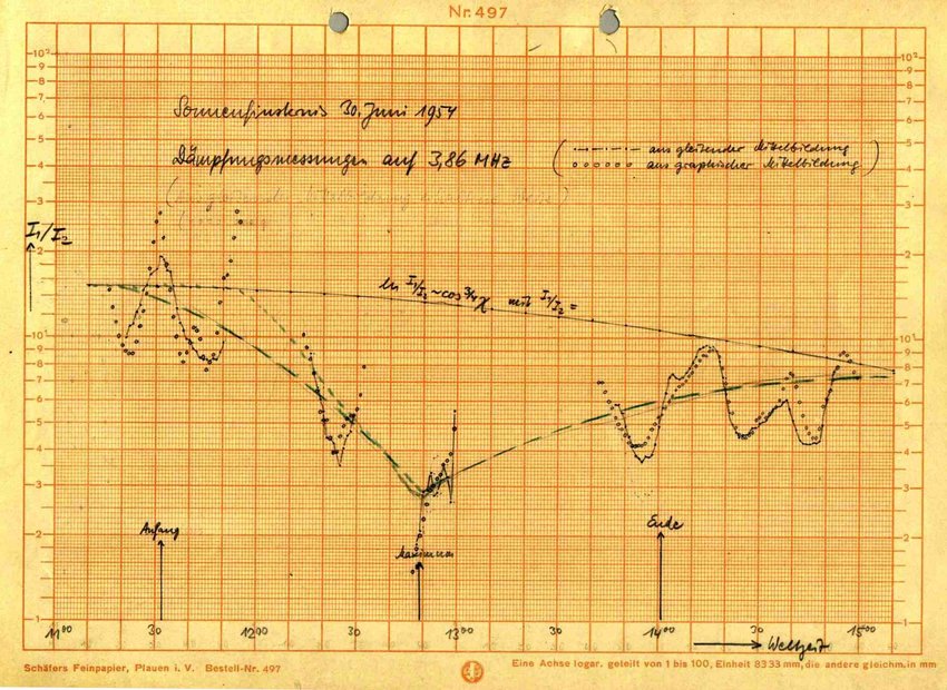
Long term reflection and refraction on matter at 250kms An Ode to the hum
Sonic Islands, Rügen – Day II, 8th September 2023
The Only Way of Discovering the Limits of the Possible Is To Venture a Little Way Past Them Into the Impossible. Arthur C. Clarke
A world far removed from (y)our own—a world where the bustling cities, the laughter of children, and the hum of technology have all vanished. In this bleak backdrop, the island of Rügen in North Germany emerges as an unlikely stage for the grand finale of our species. Imagine, if you will, a scenario with twelve other souls. These twelve are not the architects of our past, nor the saviors of our future; rather, they are re/searchers, the unlikely custodians of our legacy, and they find themselves in solitary isolation within the walls of the Field Station Juliusruh.
We arrived without really knowing what we were going for. We received the invitation to participate, and we embarked on the Terra Ignota adventure. We let ourselves be carried along a new, unknown path. In the immensity of the landscape, we could perceive our smallness, the tiny fragment we represent on this Earth. We knew that we had to merge with that landscape, to feel part of it, to understand. In that sense, it was fundamental to internalize, to understand the perception of the other members of the group. What unites us, what connects such a diverse group of people in terms of culture, trades, languages, ways of seeing life. In this extreme area of light, sea, wind, the movement of knowledge and experiences was fundamental.
On the origin and habitability of the landscape in fjords and channels of Tierra del Fuego
The region of fjords, channels, and archipelagos south of Tierra del Fuego is characterized by rugged terrain, with high and steep mountains bordered by deep incised valleys that even govern the underwater landscape. Its origin ingeniously links tectonic and climatic processes, embracing persistent uplift as a result of endogenous folding and faulting, as well as depressions and exhumations caused by the weight and carving of glaciations.
Tectonics have continuously generated, earthquake after earthquake, the development of a complex network of faults and fractures, many of which reach the surface, creating jumps in the landscape as well as zones of weakness. Pleistocene ice masses, on the other hand, have taken advantage of the slopes and areas of weakness (high concentration of fractures and rocks crushed by faults) to settle and advance. Glaciers in their upper parts have eroded and polished mountains, defining the high peaks of the Darwin Range. Moreover, as they moved, they dug and smoothed wide valleys with gentle profiles, many of which were invaded by the sea in resonance with the melting of the ice and the rising average sea level.
Tierra del Fuego region, located in the extreme south of South America, has been the subject of archaeological studies to understand the early settlement of this inhospitable and fascinating area. Archaeological findings and advances in radiocarbon dating have revealed the existence of a land bridge in the Strait of Magellan, which connected the continent with Tierra del Fuego between 13,000 and 10,000 years BP2 (Before Present) (R. D. McCulloch et al., 2005; R. McCulloch et al., 2009; Ponce et al., 2011).
There is a general consensus among researchers that the initial waves of terrestrial settlement reached the Isla Grande of Tierra del Fuego via the mentioned route in the strait. The earliest radiocarbon dating indicates an approximate age of 10,600 years BP based on samples from the Tres Arroyos site. Another early site, which has provided valuable archaeological evidence, is the Marazzi site, located southeast of present-day Bahía Inútil, dating back to 9590 years BP (Laming-Emperaire et al., 1972; Morello et al., 1999; Salemme et al., 2017). Both sites are representative of the earliest hunter-gatherer human communities that settled in Tierra del Fuego and successfully adapted to the extreme environmental conditions of the area.
The origin of this work dates back to 2015, following a visit to the Gusinde-Hagenbeck collection consisting of cultural objects originally belonging to the Kawesqar, Selk’nam, Yagán and and Aonikenk peoples, which are now housed in the Weltmuseum, Vienna (formerly the anthropological museum).
The review of this collection was initially conducted by Alfredo Prieto and Nicolás Spencer in collaboration with the curator of the South American collection, Claudia Augustat. This study aimed to achieve a more precise understanding of the objects and their anthropological value due to the different ways they were obtained; Gusinde acquired the objects through questionable anthropological purchase processes, while Hagenbeck obtained these cultural elements as “adornments” of people who were exhibited in human zoos.
For the Lapataia Valley crossing (TIF 2023) we experimented with different methods of ‘registering’ the way, time, movement, progress, rhythm, structure, topography, climate, social interaction… One attempt was a long duration recording (LDR) of the whole process. In total 416 hours of constant audio recording. Below you see the visual representation of that recording as a spectrogram mapped on the timeline. Certain events and conditions are characterized by their audible frequencies, highlighted and marked.
Reality progressively begins to transfer its own identity (what it says about itself) and its corporeality (scopic) to a synthetic panoptic device.
An orbital paranoid eye that sees everything, and from its vision gives governance, ordering of the world and synchronized reorientation of the micro-politics in each subject and each survivor tends to a unique geometry of government, exploitation and reformatting (an ocular geometry).
In order to convert everything into a surface of inscription and registration at all scales, from the genetic and psychic architecture of the living, to the zoning of macro-regions. Everything will be metadata.
A paranoid orbital eye means here, that there is a totalizing superstructure whose univocal function is attributed to be the guide of the course, the form and the time by which all living forces must be conducted at all scales.
The southern tip of America and even Antarctica has been zoned by satellites, orbital eyes that guide the routes and mark the nodes of a fabric as a prelude to future conflicts, which we can forsee.
Note I With these map sketches we try to review a Pan-American route that origins ca. 26,000 years ago in Beringia and will end in approximately 100 years in Antarctica. At this moment we can locate a modern outpost, not more than 110 years old in Antarctica, as well as a development infrastructure configuration on the other side of the Drake Passage in Tierra del Fuego.
In 2022, Fernanda Olivares and Nicolás Spencer were invited to participate in a residency at Weltmuseum to be part of the exhibition “Extinction!?” as part of the TAKING CARE project. The idea of this residency was to work with the objects belonging to the collections obtained by Martin Gusinde and Carl Hagenbeck and explore new museographic forms based on perception, feelings, the discussion around extinction, and the recognition of the Selk’nam community in Chile as a living community. >> see background
For this, we set out to investigate the objects of the Selk’nam collection, aiming to display the results for a year in the exhibition halls of this former anthropological museum. To achieve this, we approached these objects slowly and carefully, understanding that they have their own position and agency independent of the observer, a place as a consequence of a long history, with multiple meanings and ways of being interpreted. We began by understanding their ecosystem, from the periphery of the city to the elemental particles that constitute these artifacts. >> see documentation